Sequoia National Park, Lodgepole

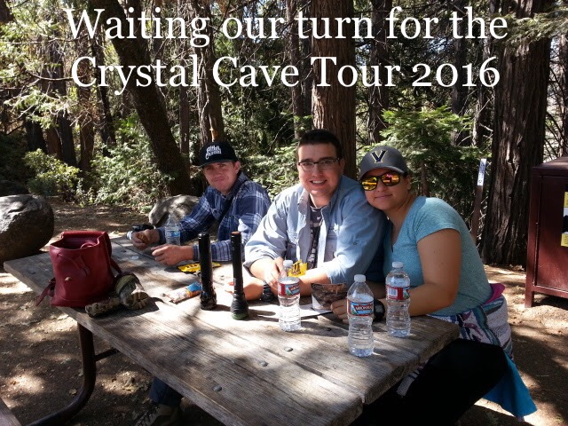
Majestic beauty in all its glory is this ginormous tree found in Kings Canyon just outside of Sequoia National Forest.  Connect with the past when you explore the beauty found in these two grand forests.  Our favorite place to camp is Lodgepole campground.  There are several trail heads found right in camp.   Campers beware this area is frequented by bears so follow the rangers suggestion and use the bear proof bins.  Remove all food an perfumy lotions from your vehicles.  Save a bear’s life and follow the rules.

4b500c5d-a429-4d3d-9d10-f6bcdcaecca9

Carpinteria – Another Great Weekend

Definetly our go-to camping spot.  Not an easy place to get in.  No last minute trips allowed.   But worth the wait.  The town of Carpinteria has that small town feel with many quaint restaurants to choose.

A must while your in town is Rincon Brewery.  Offers outdoor seating with super friendly staff.  With great BREW and FOOD.

7db1f2_85eab533deb24247aa99686d7a47ec98-mv2

Aerial View of Carpinteria State Beach


Emma Wood Beach, Ventura California

Nice weekend away from the high desert temps of 108 to the mid 70s with the Rpod.

Beautiful sunny day to enjoy a day of bike riding and camping.  Of course a weekend in Ventura  should always include Saturday morning strolling through  main street shops.  You never know what you may find.

View from the rpod’d door way. 
The roads and bike trails were a little rugged due to construction and what appears to be road improvements.  Hopefully they should be done soon.

The beach front camping is nice enough.  Rock boulders and no real sand area for kids to play at the site unless its low tide.  There is more sandy beach towards the entrance of the campground.

Honey would you please put another wood on thw fire.

Big Sur California

4th of July weekend 2016 at Big Sur was an awesome treat.  Born and raised in Southern California this was my first visit to the region.  Beautiful coastal views but I was not prepared for the quantity of people on the highway and on the trails.  The hikes were not as crowded as the Hollywood hike but still very crowded.  The beach access is very limited and we only found two routes down.  One route took us to sandy beaches where we sat with the pups and people watched.  The other route was a very nice hike down an easy path but no beach access.  Still worth the stop.  The trail took us down to an overlook near the end of low cliffs that brought us near enough to capture awesome pictures of the waves crashing against the rocks with deep blue water.  The hike was very pleasant short scenic hike over a small bridge and through a tunnel opening up to rock formations and crashing clear blue waters.  On a scale of one to five this trip was 3-1/2.

Completely off topic but interesting were the sheer number of mustang convertibles on the road tht weekend.  It seemed that around every corner and parking lot we came to there was another mustang convertible.  Over three days we counted at least two hundred mustangs in every imaginable color.

Update:  A few months after our visit the area was ravaged by wild fires.  Then the rains came in early 2017 that contributed to two major landslides that has now isolated part of the area.  The landslides engulfed the state Route 1 on Saturday, May 2017 another major landslide came down onto the Pacific Coast Trail.  The landslide covered the road, also known as State Route 1, in a 35-40 feet deep layer of dirt for about 1,500 feet. The highway is the main artery running through Big Sur, a picturesque stretch that is a major tourist attraction.

Important Safety Tips Hiking Southern California Mountains

Most important is not to take your day hike for granted. There are a few key tips to make your outing a healthy and fun day outdoors. As you take in the beauty and splendor of nature please watch the trail for loose rocks, twigs and overgrown roots for these little mis-steps and oversights have left a many scrapped knee. If you are hiking after a storm it is important to be extremely cautious along the edges of the trail. The rain may have compromised the terrain and could potentially give way. Use your common sense.

Another common danger especially in the summer months are poisonous snakes. Dont let them keep you away just be cautious. Never step over a boulder without seeing what is on the other side. Be wary of your trail because they sometimes like to bask in the summer sun. Most likely they will feel your foot vibrations and slither away. Every snake i have ever encountered was headed in the other direction.Okay you photo gurus and selfie fanatics, please be wary of your environment. Dont be over confident. Respect mother earth and the gravity pull that comes with falling over the edge. Last summer a man in our local mountains was killed while taking a selfie.

Use these important tips and enjoy your day and Don’t forget to take plenty of water.

If you would like to learn more about me and my other passions please visit my profile page.  My Profile Link.


Devils Punchbowl to Devils Chair

Oh YES!  My favorite hike this year.  Out and back is about 7.4 miles.  The sign below was at the fork in the road about a mile into the hike.   Beautiful views of geological formations formed where two titanic plates come together to form protruding rocks from the  earth.  Nice hike that begins in high desert terrain that leads into pine forests and dry creek beds to awesome geological views.  Big Horn Sheep were seen the day before our hike.  Some left over snow was still in shady areas of the hillside.  Some areas of the trail get narrow with steep drop offs.  If you are afraid of heights just look straight ahead.   Not horrible compared to some.  This hike is a great beginner to moderate because of the length of the hike.  It will take about 3 hours to complete. Next time Buckhorn Camp!

Aerial views of both Devils Punchbowl and Devils Chair.

video link


Manzanita Mountain Trail, Placerita Canyon

Placerita Canyon, Santa Clarita.  Better be in shape for this one.  And I am not.   Starts off with a grueling one mile 45 degree uphill hike.    Most definetly recommend starting from the incline and not the other way around.  Coming down that angle would be brutle on your knees.  And my 50 year old knees would NOT be happy with me.  Nicely maintained trail and a restroom and awesome views at the top.  The hike is one I most definelty will do again.  In a year after I’ve been conditioned a little more.  The views from the top are amazing.

Pacific Crest Trail, Acton California

Trailhead entrance found across the street from Indian Canyon Rd.  KOA campground entrance about 1/4 mile north.

Hike has a 2900 foot gain at the start.  Nice rock formations.  Trail passes a shallow cave.  Nice stopping point for a rest and snacks.

Hike from Griffith Observatory to Hollywood Sign

image

Meet up with LA Trail Hikers for this hike.  A great bunch of people.  The pace of the group is moderate.  The total hike ended up to be about a 7 mile round trip hike.  If you like solitare hikes and becoming one with nature this is NOT the hike for you.  It is a WELL traveled hike and there are many, many people on the trail.  On the positive side if you get lost you can ask for directions.  I now can say I’ve hiked to the Hollywood Sign.  I would recommend this hike.

Trail head was found at upper parking lot opposite of the observatory.  No hard to find.  There are restrooms available near by.

image

image


image

Create a free website or blog at WordPress.com.

Up ↑